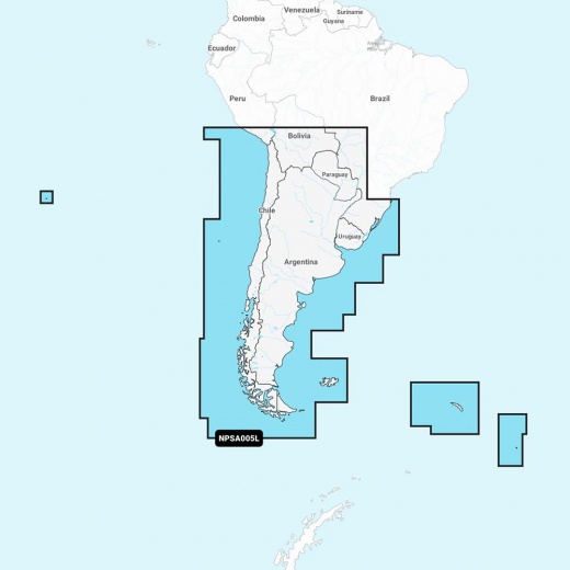
Navionics Platinum+ NPSA005L - Chile, Argentina & Easter Island
SKU: CWR-92652
Out of stock
Out of stock
- Advanced features like dock-to-dock route guidance and live mapping
- Integrated offshore and inland mapping, with over 42,000 lakes
- Relief shading to aid in shallow water navigation and satellite imagery with SonarChart shading overlay
- Customizable map options to focus on the details that matter most
- Innovative 1' (0.5 m) bathymetry charts with sonar data contributed by the boating community
Description
Experience the ultimate in marine navigation with the Navionics Platinum+ NPSA005L chart, covering the coastal waters, lakes, rivers, and more of Chile, Argentina, and Easter Island. This all-in-one solution provides detailed integrated mapping, ensuring you have the most up-to-date and accurate chart data available. With Navionics Platinum+, you'll enjoy advanced features like dock-to-dock route guidance technology, live mapping, and Plotter Sync, which gives you wireless access to daily updates. The Navionics Chart Installer software ensures the freshest chart data every time you set out.
The Navionics Platinum+ chart includes all the content of Navionics+ cartography, with integrated offshore and inland mapping, over 42,000 lakes, and additional viewing options. Enjoy relief shading to aid in shallow water navigation, satellite imagery with SonarChart shading overlay, 3D perspective view, aerial photos, and more. Get the most out of your chartplotter with advanced map options, allowing you to customize your view to focus on the details that matter most. Community Edits provide useful local knowledge from edits made by users of the Navionics Boating app, while daily updates keep your charts as accurate as possible.
SonarChart HD Bathymetry charts, created using Navionics proprietary systems, provide innovative 1' (0.5 m) bathymetry charts, augmented with sonar data contributed by the boating community. Dock-to-dock Route Guidance gives you a suggested path to follow through channels, inlets, marina entrances, and more. The SonarChart Live Mapping feature allows you to watch new HD depth maps develop in real-time as your boat moves through the water.
The Navionics Platinum+ NPSA005L chart covers South America from Arica, Chile to Rio Grande, Brazil, including Easter Island, Cape Horn, the Falkland Islands/Islas Malvinas, the South Georgia Islands, the South Sandwich Islands, and the Rio de la Plata. With the Navionics Chart Installer software, you can ensure the freshest chart data every time you set out. Compatible with a range of chartplotters, this microSD/SD card provides a comprehensive and detailed navigation solution.
Take advantage of the advanced features of the Navionics Platinum+ NPSA005L chart, including advanced route planning, live mapping, and Plotter Sync. Get the most out of your chartplotter and enjoy a safer, more enjoyable boating experience. With its comprehensive coverage and innovative features, the Navionics Platinum+ NPSA005L is the ultimate choice for boaters and anglers alike.
Whether you're planning a leisurely cruise or a fishing trip, the Navionics Platinum+ NPSA005L chart has everything you need to navigate with confidence. With daily updates, community edits, and innovative features like SonarChart Live Mapping, this chart provides the most accurate and up-to-date navigation solution available. Get the best possible boating experience with the Navionics Platinum+ NPSA005L chart.
Shipping from
This product is shipped from our supplier's warehouse in NJ, United States
Our guarantee
This product is brand new and includes the manufacturer's warranty, so you can buy with confidence.
Return policy
A 25% handling charge is levied against all authorized returns except those due to our error. Unauthorized returns are subject to a 40% handling charge. Damages & defects must be reported to us within 14 days. Product questions