Navionics NAUS008R - U.S. West - Navionics+ Chart
SKU: CWR-92610
- Access to detail-rich integrated mapping of coastal waters, lakes, rivers, and more
- SonarChart 1' (0.5 meter) HD bathymetry maps for unparalleled depth and detail
- Dock-to-dock route guidance technology, live mapping, and Plotter Sync for wireless access to daily updates
- Multiple shading options to highlight target depth range for the best fishing spots
- Up to 5,000 daily chart updates with the Navionics Chart Installer software
Unit Price
Quantity
Subtotal
US$ 224.95
US$ 224.95
US$ 223.601%
2
Description
With Navionics+, you'll have access to an all-in-one solution that offers detail-rich integrated mapping of coastal waters, lakes, rivers, and more. The chart features SonarChart 1' (0.5 meter) HD bathymetry maps, providing unparalleled depth and detail. The advanced features of Navionics+ include dock-to-dock route guidance technology, live mapping, and Plotter Sync, allowing for wireless access to daily updates.
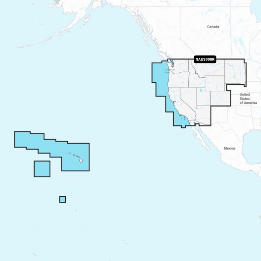
Whether you're navigating through treacherous coastal waters or exploring the tranquility of inland lakes and rivers, Navionics+ has got you covered. The chart covers an extensive area, including the lakes, rivers, and coasts of Arizona, California, Colorado, Idaho, Montana, Nevada, North Dakota, Oregon, South Dakota, Utah, Washington, and Wyoming, as well as Hawaii and the Johnston and Palmyra Atolls.
One of the most impressive features of Navionics+ is its ability to provide multiple shading options, making it easy to highlight a target depth range for the best fishing spots. The chart also includes advanced route guidance solutions, providing a suggested path to follow through channels, inlets, marina entrances, and more.
The Navionics Chart Installer software ensures that you'll always have the freshest chart data, with up to 5,000 daily updates available. Community Edits allows users to contribute local knowledge and insights, making the chart even more accurate and informative. Additionally, Plotter Sync enables seamless transfer of routes and markers, as well as chart layer updates, between your compatible chartplotter and the Navionics Boating app.
Invest in the Navionics NAUS008R - U.S. West - Navionics+ chart and experience the difference that the world's No. 1 choice in marine mapping can make. With its unparalleled accuracy, advanced features, and seamless integration with compatible chartplotters, this chart is an essential tool for any boater, angler, or water enthusiast. Upgrade your navigation experience today and discover the thrill of exploring the world's waterways with confidence.
Shipping specs
Shipping from
This product is shipped from our supplier's warehouse in NJ, United States
Our guarantee
This product is brand new and includes the manufacturer's warranty, so you can buy with confidence.
Return policy
A 25% handling charge is levied against all authorized returns except those due to our error. Unauthorized returns are subject to a 40% handling charge. Damages & defects must be reported to us within 14 days. Product questions