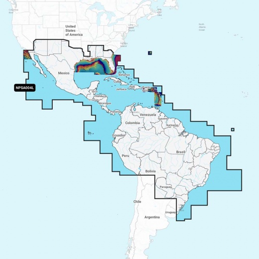
Navionics Platinum+ NPSA004L - Mexico, Caribbean To Brazil
SKU: CWR-92651
- Get unparalleled situational awareness and confidence on the water with the most up-to-date and detailed navigation solution
- Experience the ultimate in marine mapping with integrated mapping of coastal waters, lakes, rivers, and more
- Enjoy advanced features like dock-to-dock route guidance technology and live mapping with Plotter Sync
- Access daily updates with the Navionics Chart Installer software and multiple shading options for the best fishing spots
- Upgrade your navigation experience with the world's leading marine mapping brand, backed by unparalleled level of detail, accuracy, and features
Unit Price
Quantity
Subtotal
US$ 589.81
US$ 589.81
US$ 586.271%
2
US$ 584.201%
3
Description
With the Navionics Platinum+ chart, you'll have access to a wealth of features designed to enhance your boating experience. SonarChart 1' (0.5 meter) HD bathymetry maps provide incredibly detailed underwater topography, while advanced features like dock-to-dock route guidance technology ensure a safe and efficient journey. Plus, with live mapping and Plotter Sync, you'll have wireless access to daily updates, ensuring you always have the most accurate and current chart data available.
The Navionics Chart Installer software guarantees you'll always have the freshest chart data every time you head out on the water. And with multiple shading options, you can easily identify shallow water areas and highlight target depth ranges for the best fishing spots. The Navionics Platinum+ chart also includes all the content of Navionics+ cartography, with integrated offshore and inland mapping, 42,000+ lakes, and additional viewing options for relief shading, satellite imagery with SonarChart shading overlay, 3D perspective view, aerial photos, and more.
This comprehensive chart covers a vast area, including Mexico, Central America, and Brazil, as well as the US Gulf Coast and eastern US coast to Savannah, GA; Bermuda; the Bahamas; Cuba; Hispaniola; Puerto Rico and the Virgin Islands; the Windward and Leeward Islands; Jamaica; the Panama Canal, the western coast of South America to Arica, Chile; the Galapagos Islands; the Revillagigedo Islands; the Ilha Fernando de Noronha; the Saint Peter and Saint Paul Archipelago and the Rocas Atoll.
Upgrade your navigation experience with the Navionics Platinum+ chart, backed by the world's leading marine mapping brand. With its unparalleled level of detail, accuracy, and features, you'll be able to navigate with confidence, whether you're fishing, cruising, or just enjoying a day on the water.
In the box, you'll find a MicroSD/SD card, compatible with a range of chartplotters. Experience the best of marine navigation with the Navionics Platinum+ NPSA004L chart - make the most of your time on the water and discover new adventures with the world's most trusted marine mapping solution.
Shipping specs
Shipping from
This product is shipped from our supplier's warehouse in NJ, United States
Our guarantee
This product is brand new and includes the manufacturer's warranty, so you can buy with confidence.
Return policy
A 25% handling charge is levied against all authorized returns except those due to our error. Unauthorized returns are subject to a 40% handling charge. Damages & defects must be reported to us within 14 days. Product questions