Navionics Naus006r - U.S. South - Navionics+ Chartplotter Card
SKU: CWR-92608
- Unparalleled chart accuracy with daily updates of up to 5,000 changes
- Comprehensive coverage of the Gulf of Mexico, the Atlantic coasts of Florida and Georgia, the Bahamas, and the Florida Keys
- Advanced features like dock-to-dock route guidance, multiple shading options, and SonarChart 1' (0.5 meter) HD bathymetry maps
- Community Edits feature allows you to tap into the collective knowledge of the Navionics Boating app community
- Seamless transfer of routes and markers, update chart layers, and more, between your compatible chartplotter and the Boating app via Plotter Sync
Unit Price
Quantity
Subtotal
US$ 224.95
US$ 224.95
US$ 223.601%
2
US$ 222.811%
3
Description
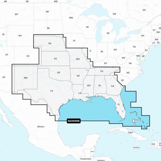
The NAUS006R chart card is specifically designed to cater to the needs of boaters, anglers, and water enthusiasts exploring the lakes, rivers, and coasts of Alabama, Arkansas, Florida, Georgia, Kansas, Louisiana, Mississippi, Missouri, Nebraska, New Mexico, Oklahoma, Tennessee, and Texas. With comprehensive coverage of the Gulf of Mexico, the Atlantic coasts of Florida and Georgia, the Bahamas, and the Florida Keys, you can rely on Navionics+ to guide you through even the most complex waterways.
What sets Navionics+ apart is its dedication to providing the most accurate and freshest chart data available. With daily updates of up to 5,000 changes, you can be sure that your chartplotter has the latest information, ensuring a safer and more enjoyable boating experience. The Navionics Chart Installer software takes care of keeping your charts updated, so you can focus on what matters most - your time on the water.
The Navionics+ cartography includes advanced features like dock-to-dock route guidance, which provides a suggested path to follow through channels, inlets, marina entrances, and more. Multiple shading options aid in shallow water navigation and make it easy to highlight a target depth range for the best fishing spots. SonarChart 1' (0.5 meter) HD bathymetry maps provide unparalleled detail, and the innovative SonarChart Live mapping feature allows you to watch new HD depth maps develop in real-time as your boat moves through the water.
Community Edits is another exceptional feature that allows you to tap into the collective knowledge of the Navionics Boating app community. This crowdsourced information adds another layer of detail to your charts, providing valuable insights from local boaters who have explored the same waters. With Plotter Sync, you can seamlessly transfer routes and markers, update chart layers, and more, between your compatible chartplotter and the Boating app.
Experience the ultimate in navigation and chartplotter functionality with the Navionics Naus006r - U.S. South - Navionics+ card. With its unparalleled accuracy, advanced features, and commitment to providing the freshest chart data, this chartplotter card is the perfect choice for boaters seeking a superior navigation experience in the southern United States.
Shipping specs
Shipping from
This product is shipped from our supplier's warehouse in NJ, United States
Our guarantee
This product is brand new and includes the manufacturer's warranty, so you can buy with confidence.
Return policy
A 25% handling charge is levied against all authorized returns except those due to our error. Unauthorized returns are subject to a 40% handling charge. Damages & defects must be reported to us within 14 days. Product questions