Garmin Bluechart G3 HD - HXAE002R - Yellow Sea - MicroSD/SD
SKU: CWR-35776
Out of stock
Out of stock
- Provides unparalleled detail and accuracy for navigating the Yellow Sea
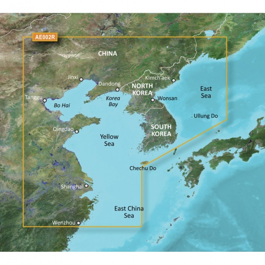
- Covers an extensive area, including Chinese, North and South Korean, and Russian coasts
- Features advanced chart plotting capabilities, including 1-foot contours and Depth Range Shading
- Includes detailed information on numerous ports and harbors, including Shanghai, Qingdao, and Dalian
- Ideal for boaters, fishermen, and outdoor enthusiasts looking to explore the Yellow Sea with confidence
Options
Description
The Garmin Bluechart G3 HD - HXAE002R covers an extensive area, including the Chinese coast from Wenzhou to Dandong, the entire North and South Korean coasts, and the Russian coast east to Nakhodka. Additionally, it includes general coverage of the southern tip of Japan from Yonago around to Kochi. With this chart, you'll have access to detailed information on numerous ports and harbors, including Shanghai, Qingdao, and Dalian in China, as well as Nampo, North Korea, Pusan, South Korea, Chongjin, North Korea, and Nagasaki and Fukuoka in Japan.
The Advanced Chart Offering from Garmin is designed to provide boaters with the most detailed and accurate information available. With its advanced chart plotting capabilities, you'll be able to navigate with confidence, even in unfamiliar waters. The system's detailed charts help guide your boat in and out of port, while the Depth Range Shading feature displays high-resolution depth information for up to 10 depth ranges. This means you can quickly and easily view your designated target depth, making it ideal for fishing, snorkeling, or simply exploring the underwater world.
The Garmin Bluechart G3 HD also features 1-foot contours, providing a more accurate depiction of bottom structure than traditional charts. This level of detail is especially useful for fishermen, who can use the information to locate the most promising fishing spots. The system also includes detailed harbors and marinas, complete with navigational aids, spot soundings, tides, and currents. Whether you're a seasoned sailor or a newcomer to the world of boating, the Garmin Bluechart G3 HD is the perfect tool for navigating the Yellow Sea.
With its advanced features and unparalleled accuracy, the Garmin Bluechart G3 HD - HXAE002R is an essential tool for anyone looking to explore the Yellow Sea. Whether you're looking to catch the big one, explore hidden coves, or simply enjoy a leisurely cruise, this chart plotting system has got you covered. With its detailed charts, advanced features, and user-friendly interface, the Garmin Bluechart G3 HD is the ultimate navigational solution for boaters, fishermen, and outdoor enthusiasts alike.
So why settle for anything less? Choose the Garmin Bluechart G3 HD - HXAE002R - Yellow Sea - microSD/SD for your next adventure on the water. With its advanced features, unparalleled accuracy, and comprehensive coverage, this chart plotting system is the perfect tool for navigating the Yellow Sea with confidence. Whether you're a seasoned sailor or just starting out, the Garmin Bluechart G3 HD is the ultimate navigational solution for anyone looking to explore this incredible body of water.
Shipping specs
Shipping from
This product is shipped from our supplier's warehouse in NJ, United States
Our guarantee
This product is brand new and includes the manufacturer's warranty, so you can buy with confidence.
Return policy
A 25% handling charge is levied against all authorized returns except those due to our error. Unauthorized returns are subject to a 40% handling charge. Damages & defects must be reported to us within 14 days. Product questions