Garmin Bluechart® G3 Vision® Hd - Veu458s - göTeborg To Fyn - Microsd™/Sd™
SKU: CWR-30770
Out of stock
Out of stock
Options
Description
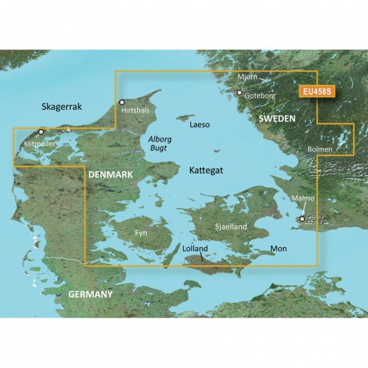
Experience the unparalleled coverage and brilliant detail of the Garmin Bluechart G3 Vision HD chart, specifically designed for the Scandinavian region. This premier coastal chart provides industry-leading coverage, clarity, and detail with integrated Garmin and Navionics content. The VEU458S chart covers the Swedish coast from Göteborg to Malmö, including lakes Mjörn and Bolmen, as well as the Danish coast from Hirtshals through Fyn, including Århus, Copenhagen, and Limfjorden.
With Auto Guidance, you can select a spot and get a route showing you the general path and nearby obstructions at a safe depth. This feature is perfect for fishing or cruising, providing you with the most optimal route while avoiding shallow waters and other hazards. The Depth Range Shading feature displays high-resolution depth ranges, allowing you to view your designated target depth and navigate with confidence. Additionally, the Shallow Water Shading feature provides a clear picture of shallow waters to avoid, allowing you to safely navigate through unfamiliar waters.
The Garmin Bluechart G3 Vision HD chart also features detailed contours, with 1’ contours that provide a more accurate depiction of bottom structure for improved fishing charts and enhanced detail in swamps, canals, and port plans. High-resolution satellite imagery with navigational charts overlaid gives you a realistic view of your surroundings, making it ideal for entering unfamiliar harbors or ports. The FishEye View feature provides a 3-D representation of the bottom and contours as seen from below the waterline, while the MarinerEye View feature provides a 3-D representation of the surrounding area both above and below the waterline.
Furthermore, the Aerial Photography feature offers crystal-clear aerial photography that shows exceptional detail of many ports, harbors, and marinas. This feature is perfect for entering unfamiliar ports or harbors, providing you with a clear understanding of your surroundings. With the Garmin Bluechart G3 Vision HD chart, you can navigate with confidence and precision, making it the perfect tool for fishermen, cruisers, and sailors alike.
The Garmin Bluechart G3 Vision HD chart is designed to provide you with the most accurate and detailed charts, giving you the confidence to navigate through unfamiliar waters. With its industry-leading coverage, clarity, and detail, this chart is a must-have for anyone who spends time on the water. Whether you're a seasoned navigator or just starting out, the Garmin Bluechart G3 Vision HD chart is the perfect tool for any marine enthusiast.
Get the most out of your Garmin chartplotter with the Bluechart G3 Vision HD chart. With its advanced features and detailed charts, you'll have the confidence to navigate through even the most unfamiliar waters. Don't settle for anything less - choose the Garmin Bluechart G3 Vision HD chart for your next adventure on the water.
Shipping specs
Shipping from
This product is shipped from our supplier's warehouse in NJ, United States
Our guarantee
This product is brand new and includes the manufacturer's warranty, so you can buy with confidence.
Return policy
A 25% handling charge is levied against all authorized returns except those due to our error. Unauthorized returns are subject to a 40% handling charge. Damages & defects must be reported to us within 14 days. Product questions