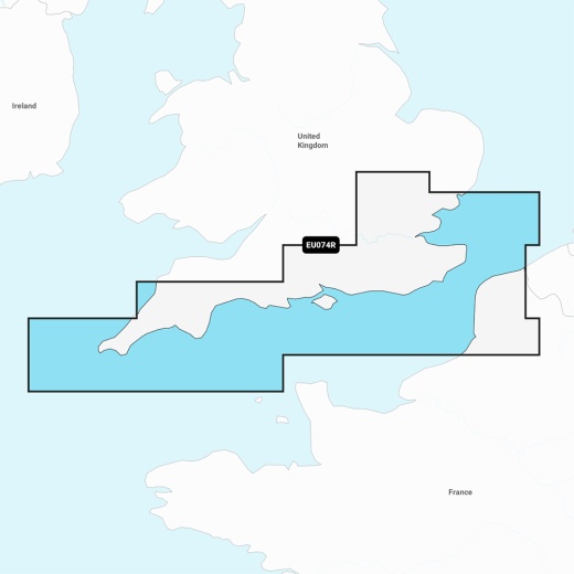
Garmin Navionics Vision+ NVEU074R Marine Chart for England, South Coast
SKU: CWR-96396
Out of stock
Out of stock
- Explore the UK's stunning south coast with unparalleled confidence
- Get the most up-to-date and detailed navigation data with daily chart updates
- Advanced Auto Guidance+ technology for a suggested dock-to-dock path
- Customizable chart layers and overlay combinations for a tailored navigation experience
- One-year subscription to daily chart updates via the ActiveCaptain app
Description
The Garmin Navionics Vision+ NVEU074R chart covers an extensive area, including the south coast of the UK from Felixstowe to the Isles of Scilly, as well as the coast of France from Dunkirk to Le Treport. You'll have access to detailed coverage of popular ports, including London, Dover, Portsmouth, Southampton, and Plymouth in the UK, and Calais in France. With daily chart updates, you can be confident that your navigation data is always current and accurate.
One of the standout features of the Garmin Navionics Vision+ NVEU074R chart is its advanced Auto Guidance+ technology. This innovative feature provides a suggested dock-to-dock path to follow through channels, inlets, marina entrances, and more, giving you peace of mind as you navigate through unfamiliar waters. Additionally, the chart's high-resolution depth range shading allows you to select up to 10 color-shaded options and view your designated target depths at a glance.
Anglers will appreciate the chart's advanced fishing features, including up to 1' contours that provide a clear depiction of bottom structure. Shallow water shading also helps you avoid navigating through treacherous waters. With the Garmin Navionics Vision+ NVEU074R chart, you'll have access to a vast community of boaters who contribute valuable information on marinas, anchorages, hazards, and more.
The Garmin Navionics Vision+ NVEU074R chart is fully customizable, allowing you to tailor your navigation experience to your preferences. With various chart layers, overlay combinations, and up to 10 color-shaded target depth ranges, you'll be able to scope out the best fishing spots with ease. Plus, with high-resolution satellite imagery and aerial photography, you'll have a crystal-clear understanding of your surroundings above and below the waterline.
When you purchase the Garmin Navionics Vision+ NVEU074R chart, you'll receive a one-year subscription to daily chart updates via the ActiveCaptain app. This means you'll always have access to the most current and accurate navigation data, ensuring a safe and enjoyable journey. With its unbeatable combination of advanced features, customization options, and unparalleled accuracy, the Garmin Navionics Vision+ NVEU074R chart is the perfect choice for any mariner looking to explore the UK's stunning south coast.
Shipping specs
Shipping from
This product is shipped from our supplier's warehouse in NJ, United States
Our guarantee
This product is brand new and includes the manufacturer's warranty, so you can buy with confidence.
Return policy
A 25% handling charge is levied against all authorized returns except those due to our error. Unauthorized returns are subject to a 40% handling charge. Damages & defects must be reported to us within 14 days. Product questions