Garmin Navionics Vision+ Nveu079r - Sweden, Southeast - Marine Chart
SKU: CWR-96377
Out of stock
Out of stock
Description
The Garmin Navionics Vision+ NVEU079R chart features a combined coastal and inland content with a popular Navionics style color palette, allowing you to customize your chart with various layers and overlay combinations. This means you can create the perfect view for your specific needs, whether you're fishing, sailing, or simply exploring the coast. With multiple shading options, you can easily highlight a target depth range and identify the best fishing spots.
When you purchase the Garmin Navionics Vision+ NVEU079R chart, you'll receive a one-year subscription to the Navionics+ cartography service. This subscription provides you with access to daily chart updates via the ActiveCaptain app, ensuring you always have the most up-to-date information at your fingertips. With over 5,000 updates made every day, you can be confident that your chart is always current and accurate.
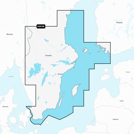
The Garmin Navionics Vision+ NVEU079R chart provides detailed coverage of the south and east coasts of Sweden, from Helsingborg to Sundsvall, including Trelleborg, Nykoping, Stockholm, Norrtalje, Karlsborg, and the southwest tip of Finland, including Turku. You'll also get coverage of the islands of Oland, Gotland, and Åland, as well as Lakes Vänern, Vättern, Sommen, Siljan, Runn, Fryken, and Helgasjön. The chart also includes the lower Dalälven from Gysinge to Söderfors, the Göta Kanal, and the Strömsholms Kanal to Smedjebacken.
With the Garmin Navionics Vision+ NVEU079R chart, you'll have access to a range of advanced features, including Auto Guidance+ technology, which provides a suggested dock-to-dock path to follow through channels, inlets, marina entrances, and more. You'll also get depth range shading, which allows you to select up to 10 color-shaded options and view your designated target depths at a glance. The chart also features up to 1' contours, providing a clear depiction of bottom structure for improved fishing charts and enhanced detail in swamps, canals, harbors, marinas, and more.
The Garmin Navionics Vision+ NVEU079R chart is compatible with a range of Garmin chartplotters and is supplied on a MicroSD/SD card. This chart is an essential tool for any serious angler, sailor, or boater who wants to ensure they have access to the most accurate and up-to-date marine mapping available. With its advanced features and unparalleled level of detail, the Garmin Navionics Vision+ NVEU079R chart is the perfect choice for anyone who wants to take their marine adventures to the next level.
Shipping specs
Shipping from
This product is shipped from our supplier's warehouse in NJ, United States
Our guarantee
This product is brand new and includes the manufacturer's warranty, so you can buy with confidence.
Return policy
A 25% handling charge is levied against all authorized returns except those due to our error. Unauthorized returns are subject to a 40% handling charge. Damages & defects must be reported to us within 14 days. Customer reviews
By feature
No reviews
Product questions