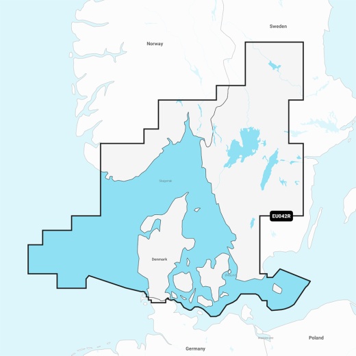
Garmin Navionics Vision+ NVEU042R - Oslo to Trelleborg - Marine Chart
SKU: CWR-96375
Out of stock
Out of stock
- Provides the most up-to-date and detailed charts for a safer and more enjoyable boating experience
- Covers the coasts of Norway and Sweden from Flekkefjord, Norway to Ystad, Sweden, and the entire coast of Denmark
- Features vibrant colors, a streamlined interface, and combined coastal and inland content with a popular Navionics style color palette
- Includes advanced technologies like Auto Guidance+ technology and daily chart updates via the ActiveCaptain app
- Compatible with a range of Garmin chartplotters and available on a microSD/SD card
Description
This chart features vibrant colors, a streamlined interface, and combined coastal and inland content with a popular Navionics style color palette, making it easy to plot your course. Multiple shading options aid in shallow water navigation and make it easy to highlight a target depth range for the best fishing spots. Moreover, the chart is fully customizable with various chart layers, overlay combinations, and up to 10 color-shaded target depth ranges to scope out the best fishing spots.
When you purchase this product, a one-year subscription is included, providing access to daily chart updates via the ActiveCaptain app. Stay ahead of the game with daily updates, adding new and amended content – up to 5,000 updates made every day.
This Garmin Navionics Vision+ chart also features advanced technologies like Auto Guidance+ technology, which combines the best of Garmin and Navionics automatic routing features to provide a suggested dock-to-dock path to follow through channels, inlets, marina entrances, and more. Additionally, the chart includes features like depth range shading, up to 1' contours, shallow water shading, and high-resolution satellite imagery, providing a clear depiction of bottom structure and superior situational awareness.
The Garmin Navionics Vision+ NVEU042R chart is compatible with a range of Garmin chartplotters and is available on a microSD/SD card. With its seamless integration with Garmin technology, this chart provides boaters worldwide with a comprehensive and reliable navigation solution.
Experience the difference with Garmin Navionics Vision+, and unlock a world of navigation possibilities. Whether you're a seasoned sailor or a newcomer to the world of boating, this chart provides the tools and features you need to navigate the waters with confidence and precision.
Shipping specs
Shipping from
This product is shipped from our supplier's warehouse in NJ, United States
Our guarantee
This product is brand new and includes the manufacturer's warranty, so you can buy with confidence.
Return policy
A 25% handling charge is levied against all authorized returns except those due to our error. Unauthorized returns are subject to a 40% handling charge. Damages & defects must be reported to us within 14 days. Product questions