Garmin Bluechart G3 Vision HD - VAE002R - Yellow Sea - MicroSD/SD Card
Out Of Stock
FIND SIMILAR PRODUCTS
Experience unparalleled navigation and explore the Yellow Sea like never before with the Garmin Bluechart g3 Vision HD - VAE002R, a premium chart offering designed to provide the most accurate and detailed mapping experience. This microSD/SD card is packed with advanced features that enhance your boating experience, making it an essential tool for mariners, fishermen, and sailors alike.
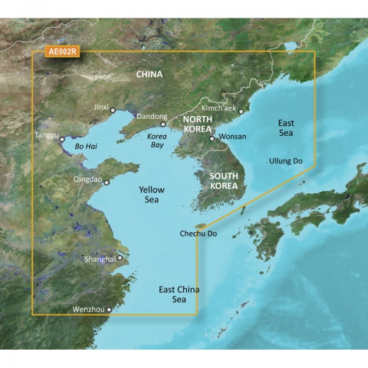
With its extensive coverage of the Chinese coast from Wenzhou to Dandong, the entire South Korean coast, and the full west coast of North Korea, this chart provides unmatched detail and accuracy. Detailed charts for areas like Shanghai, Qingdao, Dalian, Nampo, and Pusan ensure that you're always aware of your surroundings, making navigation a breeze.
One of the standout features of this chart is Garmin's Auto Guidance technology, which quickly calculates a suggested route using your boat's dimensions and a suggested path to follow, making navigation even easier. Additionally, Depth Range Shading displays high-resolution shading for up to 10 depth ranges, allowing you to view your target depth at a glance. The chart's 1-foot contours provide a more accurate depiction of the bottom structure, making it perfect for fishing charts and navigating through swamps, canals, and port plans.
The chart's three-dimensional views, including MarinerEye and FishEye, provide an additional perspective both above and below the waterline, giving you a better understanding of your surroundings. High-resolution satellite imagery with navigational charts overlaid gives you a realistic view of your surroundings, making it easy to navigate unfamiliar waters. Crystal-clear aerial photography provides exceptional detail of ports, harbors, and marinas, allowing you to enter unfamiliar ports with confidence.
Derived from official charts and private sources, this chart provides navigational aids, spot soundings, depth contours, tides, and currents, as well as detailed harbors and marinas. With Garmin's advanced features and premium chart offerings, you can be confident that you have the most accurate and up-to-date mapping data at your fingertips.
Whether you're a seasoned sailor or a casual boater, the Garmin Bluechart g3 Vision HD - VAE002R is an essential tool for anyone looking to explore the Yellow Sea. With its advanced features, extensive coverage, and unmatched accuracy, this chart is the perfect companion for your next boating adventure. So why wait? Get ready to chart your course and explore the Yellow Sea like never before.