Garmin Navionics Vision+ NVEU081R - Baltic Sea, East Coast - Marine Chart
Out Of Stock
FIND SIMILAR PRODUCTS
Experience the ultimate marine navigation with the Garmin Navionics Vision+ NVEU081R - Baltic Sea, East Coast - Marine Chart. As the world's number one choice in marine mapping, this chart provides the most up-to-date and accurate cartography for a safe and enjoyable boating experience. The vibrant colors and streamlined interface make it easy to plot your course, while the combined coastal and inland content with a popular Navionics style color palette ensures that you have the best possible view of your surroundings.
With the Garmin Navionics+ cartography, you can customize your chart with various layers, overlay combinations, and up to 10 color-shaded target depth ranges to identify the best fishing spots. The chart also features multiple shading options to aid in shallow water navigation, making it easy to highlight a target depth range. Whether you're a seasoned angler or a casual boater, this chart has got you covered.
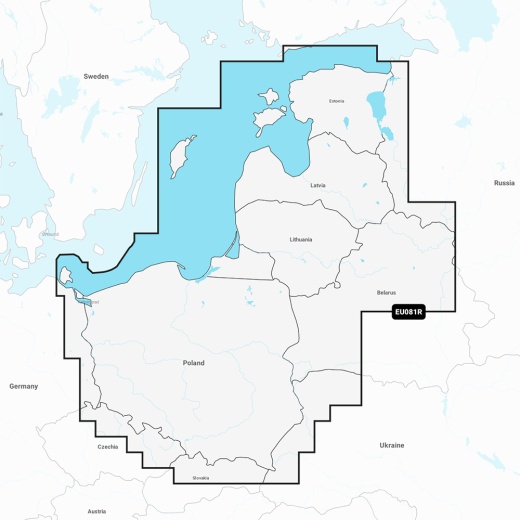
The Garmin Navionics Vision+ NVEU081R chart covers the Baltic Sea coasts of Poland, Russia, Lithuania, Latvia, and Estonia, including the Gulf of Riga, the Szczecin, Vistula and Kurshskiy Lagoons, the islands of Gotland, Saaremaa and Hiiumaa, and the Oder, Vistula, Bug, Neman, Emajõgi, and Daugava Rivers. The chart also includes coverage of lakes and rivers in Poland, Belarus, and the Baltic States, including Lakes Peipus, Pihkva, and Vörtsjäve.
One of the standout features of this chart is the Auto Guidance+ technology, which provides a suggested dock-to-dock path to follow through channels, inlets, marina entrances, and more. This feature is especially useful for navigating unfamiliar waters and ensuring safe passage. Additionally, the chart offers daily chart updates via the ActiveCaptain app, ensuring that you have access to the most up-to-date information.
The Garmin Navionics Vision+ NVEU081R chart also features advanced tools for fishing and navigation, including depth range shading, up to 1' contours, and shallow water shading. These features provide a clear depiction of bottom structure, making it easy to identify the best fishing spots and navigate through shallow waters. The chart also includes community-sourced content from the ActiveCaptain community, providing useful points of interest such as marinas, anchorages, hazards, and more.
With its advanced features, customizable interface, and unparalleled accuracy, the Garmin Navionics Vision+ NVEU081R - Baltic Sea, East Coast - Marine Chart is the ultimate tool for any boater or angler. Whether you're planning a fishing trip, a leisurely cruise, or a long-distance voyage, this chart has everything you need to navigate safely and confidently.
With the Garmin Navionics+ cartography, you can customize your chart with various layers, overlay combinations, and up to 10 color-shaded target depth ranges to identify the best fishing spots. The chart also features multiple shading options to aid in shallow water navigation, making it easy to highlight a target depth range. Whether you're a seasoned angler or a casual boater, this chart has got you covered.
The Garmin Navionics Vision+ NVEU081R chart covers the Baltic Sea coasts of Poland, Russia, Lithuania, Latvia, and Estonia, including the Gulf of Riga, the Szczecin, Vistula and Kurshskiy Lagoons, the islands of Gotland, Saaremaa and Hiiumaa, and the Oder, Vistula, Bug, Neman, Emajõgi, and Daugava Rivers. The chart also includes coverage of lakes and rivers in Poland, Belarus, and the Baltic States, including Lakes Peipus, Pihkva, and Vörtsjäve.
One of the standout features of this chart is the Auto Guidance+ technology, which provides a suggested dock-to-dock path to follow through channels, inlets, marina entrances, and more. This feature is especially useful for navigating unfamiliar waters and ensuring safe passage. Additionally, the chart offers daily chart updates via the ActiveCaptain app, ensuring that you have access to the most up-to-date information.
The Garmin Navionics Vision+ NVEU081R chart also features advanced tools for fishing and navigation, including depth range shading, up to 1' contours, and shallow water shading. These features provide a clear depiction of bottom structure, making it easy to identify the best fishing spots and navigate through shallow waters. The chart also includes community-sourced content from the ActiveCaptain community, providing useful points of interest such as marinas, anchorages, hazards, and more.
With its advanced features, customizable interface, and unparalleled accuracy, the Garmin Navionics Vision+ NVEU081R - Baltic Sea, East Coast - Marine Chart is the ultimate tool for any boater or angler. Whether you're planning a fishing trip, a leisurely cruise, or a long-distance voyage, this chart has everything you need to navigate safely and confidently.